News
May 2022
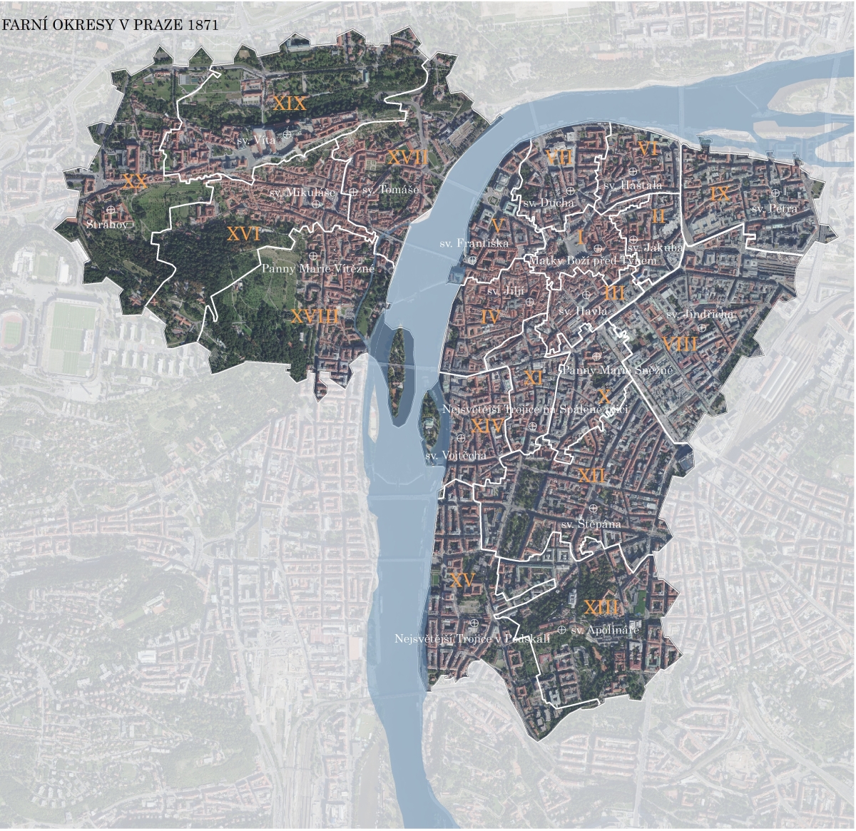
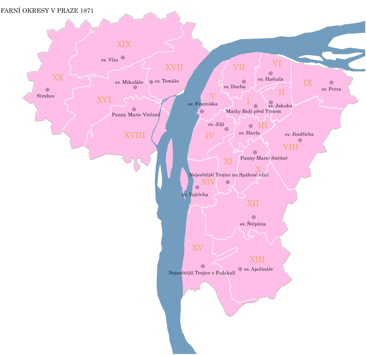
For the forthcoming Historical Atlas of the Population of Prague, the members of the cartographic team newly created the shp layer of church districts from 1871.
Our colleagues, Martin Ouředníček and Nina Dvořáková, presented the results of the project on 19 and 20 May 2022 at the 8th Brno Conference on Urban Studies entitled City: Boundaries of Imagination.
- Martin Ouředníček: Long-term development and variability of borders in Prague
- Nina Dvořáková and Jana Jíchová: Vinohrady and Žižkov on the basis of historical censuses - an area full of contrasts
November 2021
In cooperation with UpVision, s.r.o. and the Department of Applied Geoinformatics and Cartography, Faculty of Science, Charles University, took photographs of the examined Prague suburbs with the help of a drone. For the purpose of creating panoramas, a strip of photographs was always taken with a constant tilt of the camera for the area of interest. The acquired panoramas will be used in the emerging atlas and as part of the upcoming exhibition about the project.
September 2021
The 3rd and 4th sets of specialized maps dealing with the growth of selected districts in the period of socialism (Strašnice, Kobylisy, Hlubočepy, Jižní Město, Černý Most, Modřany) and the growth of suburbs in the transformation period (Jesenice, Dobřichovice, Dolní Břežany, Hostivice) were completed and published. Maps are available here.
Summer 2021
During the summer, work was underway to complete the 3rd and 4th sets of specialized maps.
The Editorial Board met several times during the summer on proposals for individual chapters of the prepared atlas.
April 2021
A geodatabase of historical spatial and statistical data for the cadastral units of Prague relating to historical population censuses was published. Data is available for download after registration here.
February 2021
Three new article have been published:
OUŘEDNÍČEK, M., PODHORSKÁ, J. (2021): Proměny obyvatelstva Prahy ve světle sčítání lidu od roku 1869 do součastnosti. Geografické rozhledy, 30(3), 12–15.
JÍCHOVÁ, J., DVOŘÁKOVÁ, N. (2021): Vinohrady a Žižkov na podkladu historických cenzů - území plná kontrastů. Geografické rozhledy, 30(3), 16–19.
PETROVIĆ, A. (2021): Vylidňování Srbska. Geografické rozhledy, 30(3), 20–21.
SOCIÁLNÍ STRUKTURA PRAHY V PRVNÍ POLOVINĚ 20. STOLETÍ V ODBORNÝCH PUBLIKACÍCH Appendix to the article: JÍCHOVÁ, J., DVOŘÁKOVÁ, N. (2021): Vinohrady a Žižkov na podkladu historických cenzů – území plná kontrastů. Geografické rozhledy, 30(3), 16–19. Available on: https://www.geograficke-rozhledy.cz/archiv/prilohy/socialni-struktura-prahy-v-prvni-polovine-20-stoleti-v-odbornych-publikacich-356.
August 2020
- The planned atlas will include, among other things, current aerial photographs of selected districts taken with a drone. In cooperation with the Department of Applied Geoinformatics and Cartography, the first test images were taken during October.
September 2020
- The first two sets of specialized maps dealing with the growth of the oldest suburbs of Prague (Smíchov, Karlín, Vinohrady, and Žižkov) and residential and industrial suburbs (Nusle, Dejvice, Záběhlice, Braník, Břevnov, Krč) were published. Maps are available here.
August 2020
- In cooperation with the State Regional Archives in Prague, a search was carried out in their archive. The result of this search was the finding of more than 100 documents that contain historical information about the area of interest.
- A visit to the State Administration of Land surveying and Cadastre archive took place, where 23 maps were photographed, which can serve as a basis for the creation of map layers showing the historical development of the boundaries of cadastres and districts in Prague and its surroundings.
June 2020
- A visit to the Prague Institute of Planning and Development took place. The purpose of this visit was to provide map materials for the creation of specialized maps.
May 2020
- A visit to the Czech Statistical Office took place, during which other documents for the solution of the project were found.
April 2020
- Based on 21 keywords, the Geography Library searched the online catalogs of 11 institutions, which preserve historical resources usable for the Prague Suburbs project. The result of this search was the finding of 1,835 resources that could potentially be used.